Great thanks to the Dry Stone Conservancy for conducting this survey.
Preliminary notes on the condition and extent of the dry stone masonry retaining walls. Town Branch Creek – Lexington, Kentucky
These notes were prepared following a visual examination carried out on February 11, 2000. Measurements were taken wherever possible, but difficulty of access on certain sections dictate that some measurements are approximate. The inspection looked at the Town Branch from Rupp Car Park to New Circle Road. The Town Branch is a creek that flows through the center of Lexington and drains broadly following the Old Frankfort Pike. The area through which it flows has been largely industrial for many years. As Lexington expanded, parts of the Town Branch were channeled and controlled with dry stone retaining walls, presumably to limit or eliminate the flood plain and to increase the availability of valuable land near the town center. These aims would have been achieved by back filling behind the retaining walls, thereby raising the grade. Dry stone masonry was extensively used throughout the Bluegrass, and this region is well known for the rock fences that still line many of the roads. Less well known is the fact that dry stone was extensively used in numerous other applications, forming the infrastructure of early agriculture, industry and transportation. Dry stone retaining walls controlled erosion and flooding on many of the creeks in the region, and those lining Town Branch represent an excellent example. These walls form the most complete example in the Lexington area and are collectively the greatest surviving concentration within the Urban County Boundary. They are therefore of considerable historic interest and importance. These walls were well built by skilled artisans. This is an important point, for much dry stone building was of inferior quality, particularly that undertaken from the late 19th C. onwards. Evidence for this lies, amongst other factors, in tight course work, adequate width of the walls and well executed core packing. There is no doubt, however, that the walls are in poor condition today. There appear to be three key factors involved.
Lack of maintenance.
Dry stone masonry has a long life, often measured in centuries. Functional and stable, minor damage to dry masonry is often ignored until significant remedial work is required. In a high stress situation, as is the case in flood control, small sections can be adversely affected by fast moving heavy debris, such as tree trunks. If these are not repaired quickly, the damage will spread with each subsequent spate. A complicating consideration may be that any damage occurs long after original construction, so that skilled personnel to effect repairs are no longer available. Two further factors have contributed to the current condition of the walls. Trees and shrubs have been allowed to grow uncontrolled over and through the masonry. The power of vegetation to damage any form of masonry is well documented, and the sheer number of plants flanking the Town Branch has had a major effect. Lastly, some of the retaining walls are built on bedrock. Usually, this is the most stable foundation, but in this instance the ledges have been eroded in places by the dissolving action of the water. This has led to failure at the toe and movement or collapse of the overlying wall.
The exceeding of load bearing capacity.
The design of a dry stone masonry retaining wall is governed by the likely stresses to be placed upon it. the loading and height increase, modifications to foundations, batter and core are required. Some of the retaining walls were backfilled. Of these, some then had to contend with the installation of railway lines in close proximity. The vibration on these lines may well have cause lateral creep that moved adjacent retaining walls outwards, particularly in the early years. In places, they have overturned. Many of the remaining backfilled walls were surcharged to a considerable height. Material has been tipped from properties adjacent to the walls; this now runs up and away from the top of the walls at a steep angle. When saturated, this material will yield pressure in excess of the bearing capacity of the underlying walls. In addition, silt creeps into the body of the wall itself , compounding the problem.
The post construction insertion of other structures.
Construction activity has continued in the years since the Town Branch was lined with dry stone masonry. A number of culverts and outflows have been installed of varying sizes. Sometimes, these were correctly inserted by re building the stonework around the pipe. Frequently, ditch was excavated to the creek, the culvert installed and the damaged stonework ignored. Major structures including railway bridges have also been installed, again with inadequate tying to the masonry in many instances.
Description and extent of Town Branch retaining walls Adjacent to Rupp Arena car park, to Patterson St. bridge.
On the north side of the car park is a retaining wall. 121′ is currently exposed, ranging in height from 2′ to 6′; more may be hidden beneath material that has been deposited along the banking. The wall is in fair condition and may well survive in its current state for many more years. There are two small gaps which require some 9′ and 6′ to be dismantled and rebuilt. On the south side of the car park, the Town Branch emerges from a culvert. Some half way along this section, the creek has been edged by two substantial retaining walls that terminate at the Patterson St. bridge. The north wall is 106′ long, and ranges in height from zero to about 8′. 30′ of the taller section has failed completely, the remainder has moved substantially and is in poor condition. The south wall measures 154′, and varies in height from 4′ to 12′. 40′ section has completely failed. This wall has also moved substantially to the extent that most overhangs the footing and is therefore close to further collapse. The wall has been surcharged by large amounts of debris comprised of soil and rubble. Much of the original stone for both walls is still present. Both require total rebuilding, and it is recommended that if this takes place the walls be increased in height by 1′ to 18″ to better retain the banking. Certain trees will need to be removed, and the final backfill be graded to a safer slope. Scaffolding would be required for the rebuilding. Currently, costs for rebuilding walls of this height range between $500 and $650 per foot length in total. This figure could be somewhat reduced with volunteer labor.
Section 2.
From Patterson Street bridge to railway bridge near Driscoll Street.
This section runs adjacent to the railway yard, extending 2,200′, and contains the greatest number of walls. The creek has been retained intermittently all along this portion. The water course also cuts through ledge rock along parts of this section, which forms solid banking at these points. The height of these rock ledges varies considerably, and where only two to three feet high, have retaining walls atop to bring the channel to an even 6′ or so of depth. On the south side, a disused rail track was supported by further walls and these also run over rock ledges, giving an overall height (ledge and wall) of approximately 12′. On portions of both sides, debris has been tipped, surcharging the walls. This length of creek is a most interesting example of blending dry stone masonry into the natural rock faces. In places, it is hard to distinguish dry stone wall from creek bank ledge. There is an unusual support wall still standing, whereby the original masons built underneath a rock overhang so that a further wall could be built above without fear of this overhang breaking. Moving west from Patterson Street Bridge, the north side has a 200′ length of 10′ wall; the largest wall in this section. The material used at this point appears somewhat inferior, as there is substantial decay of the face stones evident. Replacement of this wall would require the use of replacement rock. Keeping with the north side, there are further walls intermittently spaced, measuring approximately 20′ @ 5′ in height, 100′ @ 6′, 200′ @ 7′, 300′ @3′(overÅ“ledge), and approximately 450′ of low retaining wall, 4′ tall. On the south side, again from Patterson Street bridge, there is 60′ of eight foot high retaining wall, followed by sections spaced at varying intervals, as follows. Approximately 60′ of 6′ high wall. This is built over a 6′ high ledge rebuilding would be difficult and require scaffolding. Approximately 5′ of 4′ high wall supporting ledge (see above). 100′ of retaining wall, 6′ tall. In total, there are approximately 1520′ of retaining walls, all of which require rebuilding. In addition, it appears that there may have been lengths of wall that have totally disappeared or been buried by fill. If a program is eventually instituted to restore the Town Branch, the clearance and preparation required should reveal formal evidence of such walls. The cost of rebuilding the low retaining walls, such as the 4′ tall north bank wall, would be in the region of $90 per linear foot. This figure includes new material as required. The taller walls and those requiring scaffolding will need to be formally priced at a later date on wall by wall basis.
Section 3.
Railway Bridge near Driscoll Street to bridge under Old Frankfort Pike.
This portion encompasses that part of the Town Branch that runs south of Old Frankfort Pike. There is no stone masonry as far as could be ascertained (difficult and intermittent access) until the disused, half-standing bridge is reached. From this point until the OFP road bridge, there are dry stone retaining walls as follows: North side. There are approximately 420′ of 6′ tall retaining wall. This is in good to fair order for the most part, except for a 35′ collapse adjacent to the bridge. In addition, a small length has been concreted, which in the longer term should be restored to the original stone masonry. On the south side, again running east west from the derelict bridge, there is an 80′ section that has totally collapsed for virtually the whole length, and in addition, most of the material has washed away. The next 300′ is in fair condition. The final 40′ to the road bridge has again completely collapsed, but the stone has remained adjacent for the most part. The two collapsed sections will be impacted by the impending renewal and widening of the bridge, and representations should be made to the Kentucky Transportation Cabinet to ensure that these retaining walls are repaired and tie in to the new bridge abutments.
Section 4.
Old Frankfort Pike bridge to bridge for road number 1723.
The Town Branch is lined on both sides with 5′ high retaining walls for approximately 350′, beginning at the east end. These walls are in fair to good order, and appear to have been rebuilt sometime in the past. Little attention is required at present, although in the longer term they should be checked over so that missing stones and pins are replaced. The walls are virtually missing near the 1723 road bridge, however, and the bank appears vulnerable to erosion in this area. car park on the north side and warehousing on the south side will make replacing these walls difficult and relatively expensive. Section 5. Road bridge for 1723 to New Circle. Access was difficult for this final section. The creek was inspected in eight places and no further evidence of dry stone masonry was found. close inspection of this entire section may reveal otherwise. The Town Branch currently has approximately 440′ of retaining walls of various heights. If a rebuilding program is instituted, then some 1970′ is now in need of total rebuild, and about 1470′ may be left, at least for the present. The nature of the walls makes rebuilding difficult for the most part. Representative prices based on February 2000 data have been given to yield guidance as to the scale of the project, but it should be carefully noted that each wall will need to be accurately priced at the time. Cost savings could be made in the following areas by using volunteers and donations in kind (e.g. machinery). The clearance of rubbish from the creek bed and banks. The cutting and removal of vegetation from the walls. (The two items above are not included in the sample prices given). Stripping down the old walls, sorting out clean, reusable stone, and disposal of waste fill. The hauling in of new rock. In addition, volunteers under supervision could give limited help and gain some experience in the rebuilding process.
The Dry Stone Conservancy
3533 Winding Drive
Lexington, KY 40517
14th February, 2000
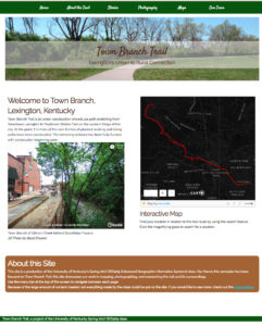 During the spring 2017 semester at the University of Kentucky, a group of 18 students in GEO 409 (Advanced Topics in GIS) created a website of maps for Town Branch Trail. The students focused on a completed alignment for the trail, which has been funded and partially completed during class. Students participated with a full spectrum of map-making and publishing; they GPS mapped and photographed points of interest, created topographic maps of the trail corridor, and made detailed, interactive maps using 3d data for building structures.